Introduction to the ‘last half mile’ – what’s been done and what’s still to do
We understand there are concerns about how people will make the last part of their journey to the new centre from public transport hubs. In response, Moorfields Eye Hospital NHS Foundation Trust has made a commitment to lead the work to support transport and access. Inspired by a quote from a patient during consultation, we call this work the ‘last half mile’.
Information on how to access the new location via public transport and on foot, including trains and tube, buses, cycle and vehicle access, is further down this page.
We have appointed accessibility and inclusion specialists from Buro Happold’s inclusive design team to work with the Oriel team, Camden Council, Transport for London (TfL) and other stakeholders to improve accessibility of the last half mile. Much of this work focuses on the patient journey and experience from public transport or vehicular drop off at the entrance of the new centre.
As a world leading specialist hospital in ophthalmology, we are committed to delivering excellent patient experience, including safe and accessible journeys from public transport links to our new location. We are committed to providing a comprehensive and robust strategy which includes traditional wayfinding methods and evolving technology to help with orientation and navigation.
Comprehensive information will be provided on all potential route options to the centre so patients are able to plan a route and method of travel that is most convenient or accessible to them.
In the summer of 2020, Buro Happold undertook audits of pedestrian routes from the six stations in scope (King’s Cross Station, St Pancras Stations, Euston Station, Mornington Crescent Station, Camden Road Station, Camden Town Station). These audits revealed that routes from some stations were shown to be too complex to navigate easily for people with sight conditions or are too long for some people to walk.
Following these comprehensive audits, a primary ‘green line’ route will be generally recommended for first visits and proposed as the most suitable route for anyone with concerns about finding their way to the centre. User engagement has confirmed that the low-tech solution of a durable, weather-resistant painted green line is robust. The intention is to start the green line between King’s Cross station St Pancras Station onto Midland Road. This line would then continue to the entrance of the new centre.
As the wayfinding strategy develops for the last half mile, we will review the potential public transport options and what further solutions may be needed to support patients and staff ahead of the new centre opening in 2027.
Getting to the new centre
The new location is in a central London location with improved connectivity to public transport from all parts of the UK, as well as offering safe routes for pedestrians and cyclists and vehicular drop off by private car or taxi.
Trains
The new location is close to three main railway stations (King’s Cross, St Pancras and Euston), making it well connected to large parts of the UK as well as to six London underground lines and the Overground.
Mornington Crescent Station, Camden Road Station and Camden Town Station are all near the new centre.
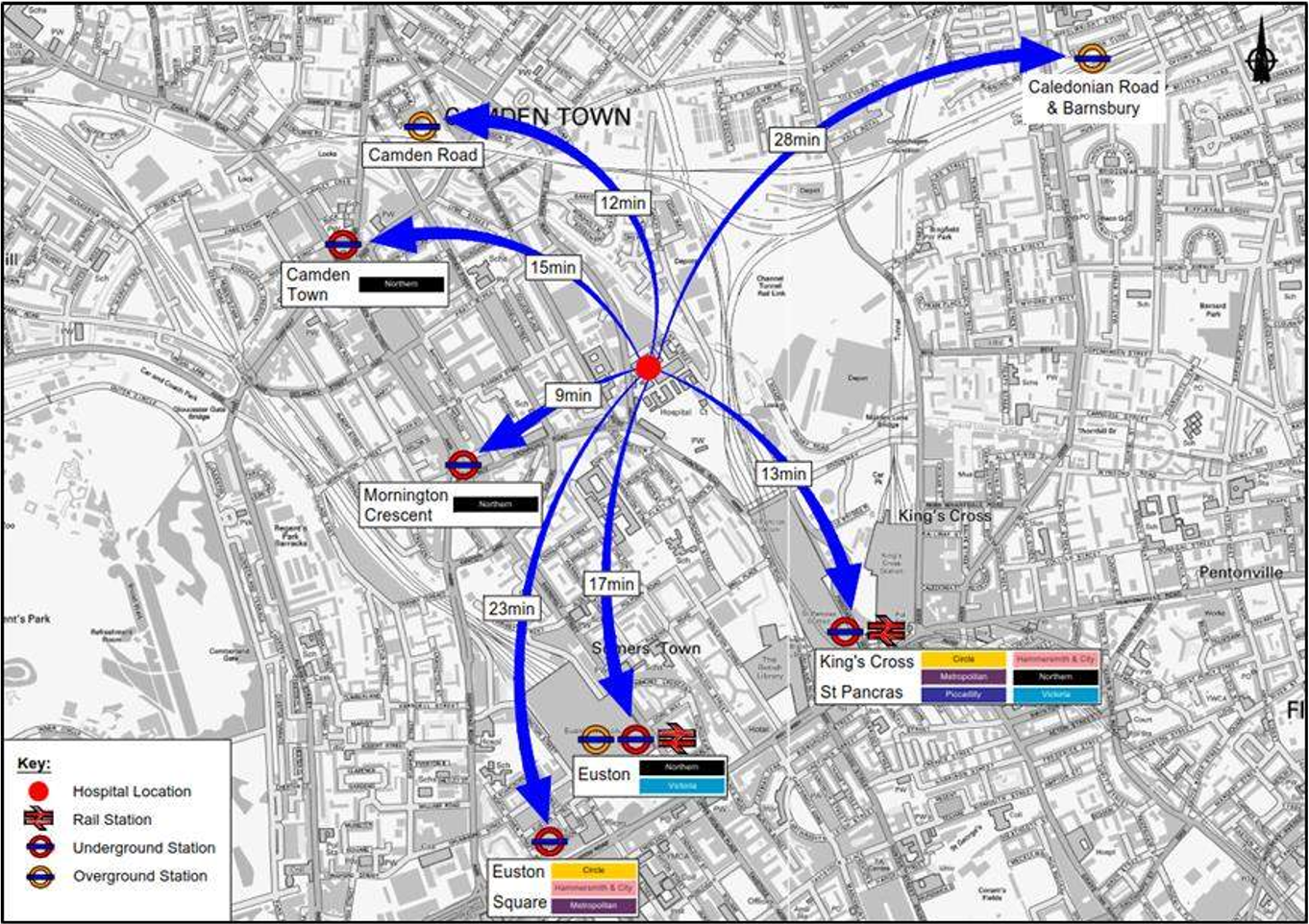
The map below shows the site and its proximity to nearby public transport options.
- King’s Cross St Pancras station is 900m from the site (an average walking time of 13 minutes).
- Euston station is 2kms from the site (an average walking time of 17 minutes).
- Euston Square station is 2.4kms from the site (an average walking time of 23 minutes).
- Mornington Crescent station is 550m from the site (an average walking time of 9 minutes).
- Camden Town station is 1.1km from the site (an average walking time of 15 minutes).
- Camden Road station is 850m from the site (an average walking time of 12 minutes).

Map of new location in proximity to nearby train stations.
Buses
The site is currently served by two bus routes: 214 – Finsbury to Highgate and 46 – Bayswater to St Bartholomew’s Hospital, Farringdon.
- 214 – Finsbury to Highgate (bus stops are approximately 250m from the new location): this route runs close to King’s Cross / St Pancras Station and enables passengers to alight in Crowndale Road, very close to the site
- 46 – Bayswater to St Bartholomew’s Hospital, Farringdon (bus stops are 350-450m from the new location): northbound access to the route is not as convenient adjoining the site. Southbound, the location of stops unfortunately does not assist potential passengers alighting from either of the Camden Stations.
Car and taxi
We anticipate that most patients will use public transport for the main part of their journey, often making the final part of their journey on foot; improved wayfinding and street enhancements are proposed. There will be vehicular drop off points close to the centre for people travelling by car:
- St Pancras Way: an extended layby for NHS patient transport services, taxi and private transport drop-off in close proximity to the A&E services on the lower ground floor.
- Granary Street: a further drop off point is proposed here, for convenient access to the north entrance where patients will enter at upper ground (reception) level.
Like many new central London sites, and consistent with Policy T6 of the London Plan, Oriel will not provide public parking on site.
Cycling
There is a cycle highway serving central London and it is also understood that the London Borough of Camden has an aspiration to complete the cycle lane on St Pancras Way, potentially by reducing the carriageway to a single lane.
The new centre will have public spaces for people to lock bikes and dedicated secure bike storage for staff. In addition to cycle parking, there are two cycle docking stations within a short walk of the site, one on Royal College Street outside the Royal Veterinary College and one on Pancras Road outside St Pancras international station.
